Sustainable Development & Freshwater Quality in Canadian Rivers
In our quest for sustainable development, a major consideration must be maintaining the water quality of our streams, rivers and other water sources. These water sources support plant and animal habitats, as well as human commercial, industrial and recreational activities.
The following article on freshwater quality trends in Canadian rivers was originally posted on the Environment Canada website but has been reproduced below for your convenience. As mentioned below, a key factor affecting the quality of water in Canadian rivers is the amount of rain and snowfall during the year, which can carry soil and pollution through runoff and leaching into the rivers. The way that construction development is performed greatly affects the sustainability of our rivers for the long term.
As the article concludes, one important factor in reversing water quality trends in our rivers is to build the health of stream banks by planting native vegetation and trees. Another important part of ensuring the long-term establishment of this vegetation is to rejuvenate and stabilize the soil with compost-based soils and growing mediums, as with Denbow’s Terraseeding service.
Freshwater Quality in Canadian Rivers
The Freshwater Quality in Canadian Rivers indicator is designed to provide an overall measure of the ability of select rivers across Canada to support aquatic life.[1] It integrates multiple pressures from human activity upstream of water quality monitoring sites to present freshwater quality in the regions where the majority of Canadians live.[2]The indicator focuses on rivers with higher risks to water quality and provides Canadians with an indication of human impacts on freshwater quality.
For the 2010 to 2012 period, freshwater quality in Canadian rivers where human activities are most concentrated was rated:
- excellent or good at 45% of monitoring sites,
- fair at 37% of sites,
- marginal at 16% of sites, and
- poor at 2% of sites.
Overall, freshwater quality in Canadian rivers can maintain healthy river ecosystems.
National freshwater quality indicator, Canada, 2010 to 2012 period
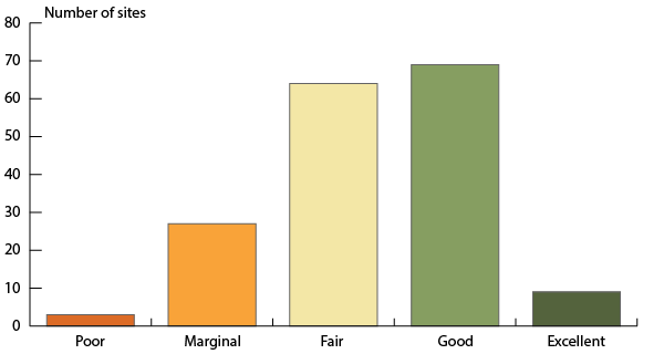
The bar graph presents freshwater quality rating in rivers selected to be representative of the regions of Canada where human activities are most concentrated for the period 2010 to 2012. The bars show the number of sites where freshwater quality was rated excellent (9), good (69), fair (64), marginal (27) and poor (3). Ratings are based on data from 172 monitoring sites.
Note: Freshwater quality was assessed at 172 sites on select rivers throughout 16 of Canada’s drainage regions where human activity is most intensive using the Canadian Council of Ministers of the Environment’s Water Quality Index.
Source: Data assembled by Environment Canada from federal, provincial, territorial and joint water quality monitoring programs.
Clean freshwater is an essential resource. It provides habitat for aquatic plants and animals, supports many commercial and industrial uses, and is at the heart of many recreational activities. Impaired water quality can undermine both aquatic ecosystem health and economic activities, such as fisheries, tourism and agriculture.
Freshwater quality varies naturally across Canada because of the country’s diverse geology and climate. It is further shaped by the ways in which people have developed the land around rivers and lakes. Each freshwater quality monitoring site has its own unique geography and set of human pressures.[3]
The rivers included in the indicators are selected to be representative of the drainage regions in Canada where human activities, such as industry, agriculture, urban growth and recreation, are most concentrated. The potential impacts of these human activities mean that these rivers are generally considered to have a higher potential for water quality impairment. At each site, physical properties of water, such as temperature, and levels of chemical substances, such as nutrients and metals, are measured and compared to freshwater quality guidelines. The more often a freshwater quality measurement is above its guidelines, the lower the freshwater quality rating will be.
Change in the national freshwater quality indicator through time
Between 2003–2005 and 2010–2012, there was an increase in the percentage of sites rated good or excellent and a decline in the percentage of sites rated poor or marginal.
Overall, the freshwater quality scores have:
- improved at 11 sites;
- declined at 4 sites; and
- showed no change at the remaining 85 sites.
National freshwater quality indicator, Canada, change between 2003–2005 and 2010–2012
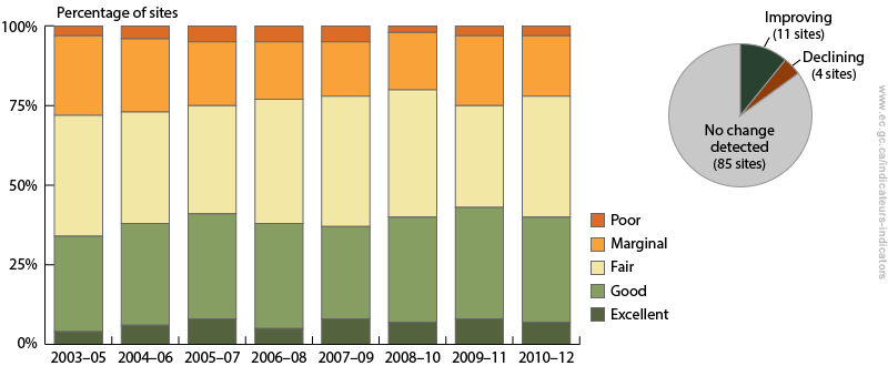
The bar graph shows the percentage of sites where freshwater quality was rated excellent, good, fair, marginal and poor between 2003–2005 and 2010–2012. The inset pie chart shows the number of sites where the freshwater quality indicator has improved, where it has deteriorated, and where no change was detected. Between 2003–2005 and 2010–2012, the freshwater quality indicator rankings have improved at 11 sites and declined at four sites. No change was detected at 85 sites.
Note: Change in the indicator between the 2003–2005 and 2010–2012 periods was assessed at 100 sites in 16 drainage regions across Canada where historical data are available. For each site, change in the indicator was assessed using a consistent set of water quality guidelines and parameters through time.
Source: Data assembled by Environment Canada from federal, provincial, territorial and joint water quality monitoring programs.
Freshwater quality is affected by rain and snow which controls how much water runs off the land or leaches through soils. It is also affected by pollution released directly into it or that travels across land and through the air. Urban growth, agricultural practices and industrial development impact how water moves across the land and change water quality along the way. These multiple pressures on water quality mean freshwater quality trends are slow to change.
The decline in water quality can be reversed by upgrading wastewater treatment plants, adopting environmental farming practices, or planting native vegetation, such as trees, along rivers.
Erosion Control – Ineffective Methods and What Actually Works
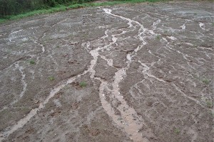
New construction creates conditions that have the potential to cause slope destabilization, dangers to wildlife and fisheries habitats; stormwater runoff increases and results in increased sedimentation. Careful erosion control planning is required to ensure environmental stewardship and safety for generations to come.
In defining an effective approach to erosion control, one should take into consideration both the long-term effectiveness as well as financial feasibility.
The following approaches and methods of erosion control have proved to be ineffective for various reasons:
 Inadequate site assessment. Though not an end solution, the site assessment is critical when determining which method is used. When important aspects of the site conditions are not taken into consideration, inappropriate “solutions” may be prescribed.
One example of a site condition is the steepness of the slope. The erosive forces of runoff increases with both slope gradient and distance down slope and therefore erosion is typically at it’s maximum at the lowest part of the steepest slope section. Not recognizing or taking into account the destructive force of water during seasonal runoff in scenarios with significant slope and distance will result in ongoing and increasing site erosion.
- A focus on sediment control (managing sediment that has already eroded) instead of focusing on the root of the erosion problem through prevention.Though silt fences and other sediment barriers may be effective in keeping stormwater and fisheries habitats from undue sedimentation, the approach should only be used temporarily. Filter socks like Denbow’s Filtersoxx can be used both as a temporary sediment barriers but also as part of a more comprehensive deployment of erosion control products. Single application solutions, not comprehensive. These methods may provide partial or temporary results but are often not effective for the following reasons:
- Engineered structures – Though usually immediately effective, engineered structures like block retaining walls, do not adapt to changing site conditions, can become progressively weaker over time and are often the most expensive solution. For this reason engineered structures are not always the best method of erosion control.
- Adding rip rap to ditches to minimize/slow runoff. In some scenarios with minimal run-off, rip rap can be effective but in instances with significant water speed and sedimentation, erosion control is not mitigated.
- Adding vegetation alone, without a structural component. Though grasses can create a groundcover that can absorb some moisture, they have no slope stabilization benefits have less effective storm water filtration ability compared to native ground cover.
Erosion Control Solutions that Work
 The solution to these incomplete and ineffective methods is to combine them into a comprehensive bio-structural approach. This approach includes engineered structural components that are paired with natural, vegetative products that will adapt and grow within the site structure over time. Starting with expert consultation to identify the appropriate method, the following are a few combination solutions available for different applications.
- Similar to hydroseeding, but providing much more of the underlying structure needed to prevent erosion, Terraseeding uses compost-based soils and growing mediums. During the Terraseeding process, seed is injected directly into the soil compost mixture as the material is blown into place, providing optimum moisture and nutrient availability.
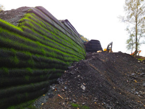
- Denbow’s Kicking Horse Canyon Park Bridge project in Golden is an perfect example of combination solutions that utilized Terraseeded EcoBlanket and Filtrexx Rip-rap Grout installed to address erosion and to vegetate extremely steep slopes.
EcoBlanket – On areas with a slope of 50% or less, EcoBlanket is uniformly applied directly at the soil surface with a pneumatic blower as specified by Rexius. Typically applied at a depth of 1 to 2 inches, but application depth can vary depending the site requirements. In extreme conditions and where specified by the Engineer, EcoBerms or FilterSoxx may be added and constructed at the top of the slope and in parallel intervals down the profile of the slope if necessary.
- Extreme slope erosion may require a natural retaining wall solution for reinforcing slopes like Cascadia Green Wall, which allows for natural buffer zone design and water gardens. It is a cost effective solution when compared to concrete, block, gabion retaining walls.
Contact Denbow for an erosion control solution that stands the test of time.
BCSLA Showcase
Tomorrow and Saturday we’re participating in the BC Society of Landscape Architects (BCSLA) 2016 Annual Conference and Showcase. Landscape Architects, visit us in booth #16 to check out our models of Cascadia Green Wall System and EcoBlanket.
Looking forward to meeting you and focusing on “Shifting Currents: Rethinking our Relationships with Water”.

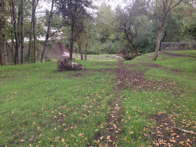
EcoBlanket Application for Erosion Control
EcoBlanket Application for Erosion Control
On this project for Metro Vancouver at 200th Street & Brydon in Langley, we applied Terraseeded™ EcoBlanket® for Metro Vancouver. Installed at the beginning of September 2015 with a low growing reclamation seed, vegetation establishment is excellent due to optimal weather for growing.
Photo taken today, fifteen days after application:
Thanks to Ryan at Scott Resources for the referral on this project.